

In-Depth PIB Analysis3 Items
Core TopicImportantConcise
Economy & InfrastructureGS Paper III
01Inland Waterways — Making 111 NWs Navigable
Science & TechnologyGS Paper III
02Martian Analogue Sites — Neyveli, Tiruchirappalli, Atacama
Internal Security & DefenceGS Paper III
03INS Samarthak — First Multi-Purpose Vessel
Economy & InfrastructureGeneral Studies Paper III
01
Inland Waterways: Surveys, Lighthouses and Digital Systems for a 111-Waterway Network
Core TopicGS-III · Economy — Infrastructure: Inland Waterways, LogisticsGS-I · Geography — Rivers & TransportPrelims + MainsPIB Backgrounder · Ministry of Ports, Shipping & Waterways · 16 Oct 2026
India has declared 111 National Waterways, but a waterway is only as useful as the depth, markings and information available to the vessel on it. A PIB backgrounder sets out how hydrographic surveys, Aids to Navigation and digital platforms are being layered onto the network — the part of waterway development that decides whether a declared waterway actually carries cargo.
◈ From the Basics — Static Background
Inland Water Transport (IWT) moves passengers and freight on rivers, canals, backwaters and creeks. India has roughly 14,500 km of navigable waterways. The declared National Waterway (NW) network is longer — 20,187 km across 23 States and 4 UTs — because declaration covers stretches that are not yet navigable.
Constitutional basis — who controls which waterway
- Entry 24, Union List (List I): shipping and navigation on inland waterways declared by Parliament by law to be national waterways, as regards mechanically propelled vessels.
- Entry 32, Concurrent List (List III): shipping and navigation on other inland waterways (mechanically propelled vessels) and carriage of passengers and goods on them.
- Entry 13, State List (List II): inland waterways and traffic thereon, subject to Lists I and III — so States remain key players outside the NW network.
- Hence only Parliament can declare a National Waterway — which is why NWs are created by Acts of Parliament.
Institutions and laws
- Inland Waterways Authority of India (IWAI): statutory body under the IWAI Act, 1985; constituted on 27 October 1986; HQ Noida; under the Ministry of Ports, Shipping and Waterways (MoPSW). It develops and regulates NWs.
- National Waterways Act, 2016: declared 106 new NWs, taking the total to 111 (the 5 earlier NWs were subsumed).
- Inland Vessels Act, 2021: replaced the Inland Vessels Act, 1917; a single national framework for registration, safety and manning, with registration valid across States.
- Marine Aids to Navigation Act, 2021: replaced the Lighthouse Act, 1927; gives statutory recognition to Aids to Navigation (AtoN) and Vessel Traffic Services.
▤ The First Five National Waterways — Prelims Staple
- NW-1 (1986): Ganga–Bhagirathi–Hooghly, Haldia–Prayagraj, 1,620 km — the longest National Waterway.
- NW-2 (1988): Brahmaputra, Dhubri–Sadiya (Assam), 891 km.
- NW-3 (1993): West Coast Canal, Kottapuram–Kollam with the Champakkara and Udyogamandal canals (Kerala), 205 km.
- NW-4 (2008): Kakinada–Puducherry canals with stretches of the Godavari and Krishna.
- NW-5 (2008): East Coast Canal with the Brahmani river and Mahanadi delta (Odisha–West Bengal).
111National Waterways
20,187 kmDeclared length
32Operational NWs
218 MMTCargo, 2025–26
20.13%CAGR since 2014–15
Figure 1 — Cargo on inland waterways, 2014–15 vs 2025–26
Million metric tonnes (MMT)050100150200MIV-2030 target: 200 MMT292182014–152025–26≈7.5× in 11 yearsCAGR 20.13%
Reported IWT cargo has already crossed the Maritime India Vision 2030 target of 200 MMT. Data: Ministry of Ports, Shipping & Waterways; chart redrawn by Legacy IAS.
What the backgrounder lays out — four layers of navigation support
Figure 2 — The navigation stack on National Waterways
1 · KNOWHydrographic surveys• Thalweg surveys• Least Available Depth• 22 NWs + IBP route• Weekly to monthly2 · MARKAids to Navigation• Lighted FRP buoys• Beacon lamp posts• Riverine lighthouses• AtoN Act, 20213 · DIGITISEe-Navigation• ENCs on 18 NWs• PANI portal• LADIS depth data• IWAI Vessel Tracker4 · MANAGETraffic management• Naudarshika (2025)• River InformationServices (RIS)• Vessel–shore linkOutcome sought: predictable, round-the-clock (24×7) navigation on National Waterways
Declaration creates a waterway in law; these four layers make it usable in practice.
Layer 1 — Hydrographic surveys: knowing the river
Hydrography measures and describes water bodies — bed structure, depth, flow direction and hazards — chiefly to produce navigation charts. A river channel shifts with season, silt and floods, so the navigable route cannot be read from the surface and has to be surveyed repeatedly.
- Thalweg surveys track the deepest continuous channel along a stretch. As of September 2026, regular thalweg surveys covered 22 NWs, run weekly, fortnightly or monthly depending on how fast the river changes.
- The Indian portion of the Indo-Bangladesh Protocol (IBP) route is also monitored — the transit network under the Protocol on Inland Water Transit and Trade, first signed in 1972.
- Terminal and jetty surveys check depth and approach conditions at berths.
- Least Available Depth (LAD) — the minimum water depth in a channel for a given stretch and period — sets the permissible vessel draft, and therefore cargo per trip, scheduling and seasonal operations.
◈ Concept Check — Thalweg
The thalweg (German: “valley way”) is the line joining the deepest points of a river channel. Besides navigation, it underpins the thalweg principle in international law, under which a boundary along a navigable river follows the middle of its main navigable channel.
Layer 2 — Aids to Navigation: marking the river
- Under the Marine Aids to Navigation Act, 2021, an AtoN is a device, system or service external to the vessel that improves safe navigation — lighted buoys, radar beacons, channel markers, lighthouses, lightships.
- Directorate General of Lighthouses and Lightships (DGLL) manages AtoN along the coast and is the national authority for training on AtoN and Vessel Traffic Services (VTS); IWAI maintains AtoN on National Waterways.
- India is party to SOLAS (International Convention for the Safety of Life at Sea, 1974) of the IMO, which obliges contracting governments to provide appropriate aids to navigation, and follows IALA guidelines.
- NW-3 (Kerala) is the model case: 312 solar-powered lighted FRP buoys and 17 beacon lamp posts support 24×7 navigation on the entire stretch.
Layer 2A — India’s first riverine lighthouses on NW-2
In March 2026, the Government announced four riverine lighthouses on the Brahmaputra (NW-2) — the first lighthouse infrastructure on any Indian inland waterway. The ₹74-crore project pairs navigation support with weather sensors and public/tourism facilities.
▤ Project at a Glance — NW-2 Riverine Lighthouses
- Locations: Pandu (Guwahati), Silghat, Biswanath Ghat, Bogibeel — all in Assam.
- Cost: ₹74 crore. Nodal body: IWAI, under MoPSW.
- Structure: towers 20 m above ground; fully solar-powered; weather-observation sensors.
- Geographical range: 14 nautical miles; luminous range: 8–10 nautical miles.
- Add-ons: museums, amphitheatres, cafeterias, landscaped spaces, children’s play areas, souvenir shops.
- NW-2 cargo: 0.90 MMT (2024–25) → 1.29 MMT (2025–26), a rise of about 43%.
Figure 3 — NW-2 and the four riverine lighthouse sites (schematic)
WEST ◂ Brahmaputra · National Waterway-2 · Dhubri → Sadiya · 891 km ▸ EASTDhubriPanduSilghatBiswanath GhatBogibeelSadiyaW terminus · IBP linkGuwahatiNagaonBiswanathDibrugarhE terminusLighthouse sites — ₹74 crore · 20 m towers · solar-powered · luminous range 8–10 nmSchematic — stations in west-to-east order; distances not to scale
All four sites lie between Guwahati and Dibrugarh; Dhubri, at the western end, links NW-2 to the IBP route through Bangladesh.
◈ Concept Check — Geographical vs Luminous Range
- Geographical range: the farthest distance at which a light can be seen as limited by the Earth’s curvature — it depends on the height of the light and of the observer’s eye.
- Luminous range: the farthest distance set by the light’s intensity and the prevailing atmospheric visibility.
- The effective range is the lower of the two. 1 nautical mile = 1,852 m.
▤ Accuracy Note
- The backgrounder describes NW-2 as the longest navigable stretch of any Indian waterway. By declared length, NW-1 (1,620 km) is the longest National Waterway; NW-2 (891 km) is the principal waterway of the North-East. Use the standard figures in answers.
Layers 3 & 4 — Digital navigation and traffic management
- Electronic Navigational Charts (ENCs): prepared for 18 operational and tidal waterways (as of September 2026). Before 2014, digital charts existed only for NW-1 (Haldia–Prayagraj).
- PANI (Portal for Asset and Navigation Information): a single platform for fairways, terminals, cross-river structures, jetty connectivity and emergency services.
- IWAI Vessel Tracker + PANI: together a web and mobile e-navigation system with real-time vessel tracking, updated routes and depth data.
- LADIS (Least Available Depth Information System): publishes depth availability for planning voyages.
- Naudarshika — National River Traffic and Navigation System (2025): a dedicated river-traffic management layer using real-time LAD.
- River Information Services (RIS): combines vessel tracking, weather and water sensors and IT systems, enabling vessel–control centre communication — the river equivalent of traffic control.
Lineage — how the policy reached here
- 1985–86: IWAI Act → IWAI set up; NW-1 (1986), NW-2 (1988), NW-3 (1993), NW-4 and NW-5 (2008) declared.
- 2016: National Waterways Act → network expands from 5 to 111; Jal Marg Vikas Project on NW-1 (World Bank-assisted) builds terminals and navigation capacity.
- 2021: Maritime India Vision 2030 sets the 200 MMT IWT target; Inland Vessels Act and Marine Aids to Navigation Act modernise the legal base.
- 2023 onward: Maritime Amrit Kaal Vision 2047; demand-side support through the Jalvahak cargo-promotion scheme (reimbursing up to 35% of operating cost on select IBP-linked routes) and extension of tonnage tax to inland vessels.
- 2025–26: Naudarshika launched; riverine lighthouses announced on NW-2.
Why it matters
- Cost and emissions: the Government puts the cost of moving a tonne by water at roughly one-third of road and half of rail, with a fraction of the carbon emissions.
- Decongestion: bulk cargo on water frees highways and rail for passengers and time-sensitive freight — a goal of PM Gati Shakti multimodal planning.
- North-East access: NW-2 and the IBP route give the region a water corridor beyond the narrow Siliguri Corridor; tea, coal and fertiliser supply chains use NW-2.
- Safety and reliability: depth data and AtoN reduce groundings and allow night sailing, which cuts transit time.
The critical view
- Declared is not navigable: only 32 of 111 NWs (about 29%) are operational; many declared stretches lack assured depth year-round.
- Concentration of traffic: NW-2’s 1.29 MMT is only about 0.6% of the national 218 MMT — the headline growth comes from a few corridors, not the network as a whole.
- Seasonality and flows: lean-season depth depends on monsoon flows, upstream abstraction and barrages; the braided, sediment-heavy Brahmaputra shifts its channel constantly.
- Dredging and ecology: maintenance dredging is recurring and costly and can disturb habitats such as the Gangetic dolphin (National Aquatic Animal) on NW-1, including the Vikramshila Gangetic Dolphin Sanctuary (Bihar).
- Tourism add-ons: amphitheatres and cafeterias on flood- and erosion-prone banks raise questions of upkeep and of diluting a navigation-safety project.
- Federal coordination: non-NW waterways sit with States (Entry 13, List II), so last-mile connectivity needs Centre–State alignment.
◈ Institutions & Terms to Know
- IWAI (statutory, 1986) · DGLL (coastal AtoN) · IMO (SOLAS) · IALA (AtoN standards)
- Thalweg · LAD · Draft (depth of a vessel below the waterline) · Fairway (maintained navigable channel)
- ENC · PANI · LADIS · Naudarshika (NRT&NS) · RIS · FRP buoys
- Protocol on Inland Water Transit and Trade (1972) — India–Bangladesh
✎ Mains Practice Question
“Declaring National Waterways is a legal act; making them navigable is an engineering and institutional task.” Examine the recent measures to improve navigation safety on India’s inland waterways and the constraints that continue to limit their use. 15 marks · 250 words
Linked PYQ (UPSC Mains 2016): Enumerate the problems and prospects of inland water transport in India.
Science & TechnologyGeneral Studies Paper III
02
Mars on Earth: Neyveli, Tiruchirappalli Badlands and Atacama Identified as Martian Analogue Sites
ImportantGS-III · S&T — Space, Planetary ScienceGS-I · Geography — Minerals, Deserts, LandformsPrelims + MainsPIB · Ministry of Science & Technology (DST) · 16 Oct 2026
A University of Kerala team using a DST-FIST-funded laser Raman spectrometer has identified melanterite at Neyveli and gypsum in the Tiruchirappalli Badlands (both Tamil Nadu) and the Atacama Desert (Chile) — hydrous sulphates that record water–rock interaction, making these sites useful terrestrial analogues for Mars.
◈ From the Basics — Static Background
A planetary (terrestrial) analogue is a place on Earth whose geology, chemistry or environment resembles another planetary body. Scientists use analogues to test instruments, train rover teams and interpret data, because orbital spectra alone cannot fully characterise Martian minerals.
- Water on Mars: sulphates and clay minerals are key evidence of past liquid water. NASA’s Opportunity rover found jarosite (acidic water) at Meridiani Planum; Curiosity found gypsum veins in Gale Crater; Perseverance is exploring Jezero Crater, a former lake delta.
- Earlier Indian analogues: Ladakh (Puga, Tso Kar — cold, high-altitude, hydrothermal), Kachchh (Matanumadh — jarosite), Lonar Crater (Maharashtra — impact crater in basalt).
- India at Mars: the Mars Orbiter Mission (Mangalyaan) was launched on PSLV-C25 on 5 November 2013 and entered Mars orbit on 24 September 2014 — India became the first Asian nation to reach Mars orbit and the first to do so on its maiden attempt.
▤ Study at a Glance
- Research team: Department of Geology, University of Kerala.
- Instrument: laser Raman spectrometer funded under DST-FIST.
- Findings: melanterite — Neyveli; gypsum — Atacama Desert and Tiruchirappalli Badlands.
- Published in: two papers in the Journal of Geophysical Research: Planets.
- Next step: rare analogue sites in extreme environments worldwide for astrobiology studies of primitive life.
The two minerals, decoded
- Gypsum (CaSO₄·2H₂O): hydrated calcium sulphate, Mohs hardness 2. Forms when sulphate-rich water evaporates; it preserves evidence of past aqueous environments and can trap biosignatures in its crystal matrix.
- Melanterite (FeSO₄·7H₂O): hydrated iron sulphate, water-soluble and short-lived. It forms when iron sulphides such as marcasite/pyrite (FeS₂) oxidise in wet, acidic, oxidising conditions — a transient water signal.
- Mars relevance: both are hydrous sulphates; the sulphide-oxidation route behind melanterite is one of the processes thought to have produced sulphates on Mars.
- Everyday link: gypsum is a set-retarder in cement, the raw material of Plaster of Paris (CaSO₄·½H₂O), and is used to reclaim sodic (alkaline) soils. The chemistry that makes melanterite also drives acid mine drainage.
Figure 4 — How melanterite forms at Neyveli: lignite → marcasite → melanterite
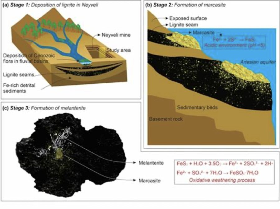
Cenozoic plant matter becomes lignite; iron sulphide (marcasite) forms in acidic (pH < 5) conditions; oxidative weathering then yields melanterite. Image courtesy PIB / DST (University of Kerala research team); reproduced with credit for educational use.
The sites — geography you can be tested on
- Neyveli (Cuddalore district, Tamil Nadu): India’s best-known lignite field, mined by NLC India Ltd (a Navratna CPSE under the Ministry of Coal). Lignite (“brown coal”) is a low-rank coal; Tamil Nadu holds the largest share of India’s lignite reserves. The lignite seams overlie artesian aquifers.
- Atacama Desert (Chile): the driest non-polar desert, shaped by the cold Humboldt (Peru) Current, the persistent South Pacific subtropical high and the rain shadow of the Andes. Its hyper-arid, UV-intense soils make it a long-standing Mars test-bed.
- Tiruchirappalli Badlands (Tamil Nadu): a semi-arid terrain of geological and palaeoclimatic interest. Badlands are deeply gullied, sparsely vegetated landscapes carved in soft sediments — the Chambal ravines are India’s best-known example.
Figure 5 — Why analogue sites matter for planetary missions
Orbiter spectraRemote, coarsesignals from MarsEarth analogueSimilar minerals,accessible terrainLaser RamanSpectral fingerprintconfirms mineralMission designBetter landing &sampling targetsAnalogues “ground-truth” what orbiters can only infer
Raman instruments now fly on Mars rovers too, so Earth-based reference spectra feed directly into rover science.
◈ Concept Check — Raman Spectroscopy
- Based on the Raman effect — inelastic scattering of light — discovered by C.V. Raman on 28 February 1928 (Nobel Prize in Physics, 1930); the date is marked as National Science Day.
- Each mineral gives a unique vibrational “fingerprint”; the method is non-destructive and needs little sample preparation.
- On Mars, Perseverance carries Raman instruments (SuperCam, SHERLOC); ESA’s Rosalind Franklin rover is designed with a Raman Laser Spectrometer.
- DST-FIST — Fund for Improvement of S&T Infrastructure in Universities and Higher Educational Institutions (launched 2000) — funds such research equipment in university departments.
Why it matters
- Ground-truthing: verified mineral signatures help interpret orbital and rover data from Mars.
- Astrobiology: gypsum’s ability to preserve biosignatures makes such deposits priority targets in the search for past life.
- Future Indian missions: home-grown analogue science strengthens India’s capacity to plan landing sites and payloads for follow-on planetary missions.
- University research: shows the returns from funding shared instrumentation beyond national laboratories.
The critical view
- No perfect analogue: Mars has lower gravity, a thin CO₂ atmosphere, intense UV radiation and extreme cold — each analogue matches only some conditions.
- Site loss: Neyveli is an active mine; analogue exposures can be destroyed by mining or erosion without a national inventory or protection mechanism.
- Funding continuity: high-end instruments in universities need sustained support for maintenance and trained staff, not one-time grants.
✎ Mains Practice Question
What are terrestrial analogue sites in planetary science? Discuss how India’s geological diversity can support its future planetary exploration and astrobiology research. 10 marks · 150 words
Internal Security & DefenceGeneral Studies Paper III
03
INS Samarthak: Navy Commissions Its First Multi-Purpose Vessel, Built by a Private Indian Shipyard
ImportantGS-III · Security — Defence Indigenisation, Maritime SecurityPrelims + MainsPIB · Ministry of Defence · Vice-President’s Secretariat · 16 Oct 2026
INS Samarthak, the first of two Multi-Purpose Vessels (MPVs) built by Larsen & Toubro (L&T), was commissioned at Naval Base Karwar on 16 October 2026 in the presence of the Vice-President and the Chief of the Naval Staff. Its main job is to serve as a trials platform for indigenous weapons and sensors.
◈ From the Basics — Static Background
An MPV is a support platform rather than a frontline combatant: it tows, tests, patrols and assists. Navies need such ships so that weapon and sensor trials do not tie up frigates and destroyers meant for operations.
India’s warship-building journey
- INS Nilgiri (1972): the first major warship built in India — a Leander-class frigate from Mazagon Dock, Mumbai.
- INS Vikrant (2022): India’s first indigenous aircraft carrier, built by Cochin Shipyard, commissioned on 2 September 2022.
- Shipyards: defence PSUs under the Department of Defence Production — Mazagon Dock, GRSE (Kolkata), Goa Shipyard, Hindustan Shipyard (Visakhapatnam); Cochin Shipyard under MoPSW; and private yards such as L&T Kattupalli (near Chennai).
Policy architecture for indigenisation
- Defence Acquisition Procedure (DAP) 2020: ranks Buy (Indian-IDDM) — Indigenously Designed, Developed and Manufactured — as the highest-priority category, followed by Buy (Indian).
- Strategic Partnership model (2017): lets Indian private firms partner foreign OEMs in submarines, fighter aircraft, helicopters and armoured vehicles.
- Positive Indigenisation Lists: items the Services must source domestically after set timelines.
- 2025 maritime package (₹69,725 crore): support for commercial shipbuilding through a financial-assistance scheme, a Maritime Development Fund and a shipbuilding development scheme.
▤ Ship at a Glance
- Contract: signed 25 March 2022 by the Ministry of Defence with L&T for two MPVs, ₹887 crore, under the “Buy (Indian)” category.
- Builder: designed in-house and built at L&T Shipyard, Kattupalli (Tamil Nadu); modular construction with pre-outfitting.
- Milestones: launched 14 October 2024 · delivered 27 August 2026 · commissioned 16 October 2026, Karwar.
- Indigenous content: over 75%.
- Size and speed: about 107 m long, displacement over 3,750 tonnes, top speed 15 knots.
- Name: Samarthak — “The Proponent”. The second MPV is under construction at Kattupalli.
Figure 6 — INS Samarthak at its commissioning, Naval Base Karwar
The ship joins the fleet as a dedicated trials-and-support platform. Image courtesy PIB / Ministry of Defence; reproduced with credit for educational use.
Figure 7 — From contract to commissioning
≈15-month slip25 Mar 2022Contract · 2 MPVs · ₹887 crMay 2025Delivery originally due16 Oct 2026Commissioned · Karwar14 Oct 2024Launched · Kattupalli27 Aug 2026Delivered to Navy
Deliveries were scheduled to begin in May 2025; the first ship arrived in August 2026.
What the ship will do
- Trials and evaluation: testing new indigenous sensors and weapons, including launch and recovery of torpedoes and operating aerial, surface and underwater targets for gunnery and anti-submarine warfare (ASW) firing exercises.
- Uncrewed systems: operating autonomous / uncrewed vehicles.
- Operations: maritime surveillance and reconnaissance, offshore patrol, towing of ships.
- HADR: Humanitarian Assistance and Disaster Relief, with a limited hospital-ship capability.
◈ Place in News — Karwar
Naval Base Karwar (INS Kadamba) lies in Uttara Kannada district, Karnataka. Its expansion under Project Seabird is building one of the Navy’s largest bases on the west coast.
Why it matters
- Faster indigenous development: a dedicated test ship shortens the cycle for systems from DRDO labs such as the Naval Science & Technological Laboratory (NSTL), Visakhapatnam — designer of the Varunastra heavyweight torpedo — and from private industry.
- Frontline ships freed: combatants no longer have to be diverted for trials duty.
- Private-yard capability: the Navy describes it as the first major warship built by an Indian private shipyard, widening the industrial base beyond the defence PSUs.
- Non-traditional threats: piracy, trafficking, IUU fishing, drone attacks on shipping and climate disasters call for versatile hulls — in line with MAHASAGAR (2025, successor to SAGAR, 2015) and the Information Fusion Centre–IOR (Gurugram, 2018).
The critical view
- Schedule slip: delivery came about 15 months after the contracted start date — timelines remain the weak link in naval shipbuilding.
- Framing: an MPV is an auxiliary, not a combatant; L&T has earlier built offshore patrol vessels for the Coast Guard, and a 2011 private-yard contract for naval offshore patrol vessels ran into prolonged delays and builder distress.
- Quality of indigenisation: “75% indigenous content” is measured by value; critical subsystems such as propulsion and some sensors may still be imported.
- Order-book continuity: private yards need a steady pipeline and a level playing field with PSU yards to sustain skilled workforces.
✎ Mains Practice Question
The induction of naval platforms built by private shipyards marks a shift in India’s defence-industrial model. Discuss the opportunities and constraints in expanding private participation in naval shipbuilding. 15 marks · 250 words