

In-Depth PIB Analysis3 Items
Core TopicImportantConcise
Science & TechnologyGS Paper III
01Pollen Records, 4.2 ka Event & Harappan Civilisation Decline02Himalayan Chandra Telescope — 25 Years at Hanle
Polity, Governance & Social JusticeGS Paper II
03DAANVEER Initiative — Digital Infrastructure for Gram Panchayats
Science & TechnologyGeneral Studies Paper III
01
Pollen Records From Garhwal Lake Illuminate the Collapse of Harappan Civilisation
GS-III · S&T — Palaeosciences, ClimateGS-I · Ancient History — Harappan CivilisationPrelims + MainsPIB · DST / BSIP · 29 Jul 2026
A high-resolution pollen study from Deoria Tal (Garhwal Himalaya) by the Birbal Sahni Institute of Palaeosciences has linked an abrupt monsoon failure at 4,200 years BP to the eastward contraction of the Harappan (Indus Valley) Civilisation — providing the strongest Himalayan palaeoclimate evidence yet for the globally recognised "4.2 ka event."
◈ Background & Context
The Indus Valley Civilisation (IVC), also called the Harappan Civilisation, was the largest of the three early Bronze Age urban civilisations — alongside Mesopotamia and Egypt — flourishing between approximately 3300 and 1300 BCE across present-day northwestern India and Pakistan.
- Geographical core: the Indus River system (including the Jhelum, Chenab, Ravi, Beas, Sutlej) and the now-desiccated Ghaggar-Hakra river system, which many scholars identify with the Vedic Sarasvati.
- Key urban centres: Mohenjo-daro, Harappa (type-site), Rakhigarhi (largest known site), Dholavira (UNESCO, 2021), Lothal (early dock), Kalibangan, Banawali and Chanhu-daro.
- Mature Phase (c. 2600–1900 BCE): standardised weights & measures, fired-brick cities with grid plans, covered drains, and a still-undeciphered script.
- Long-standing question: why the urban core contracted and population migrated eastward toward the Ganga plains after ~2000 BCE has been debated for over a century — theories range from Aryan invasions (now largely discredited) to tectonic shifts, river avulsions, and climate change.
Figure 1 — Spatial Extent of the Harappan Civilisation (Mature Phase, c. 2600–1900 BCE)
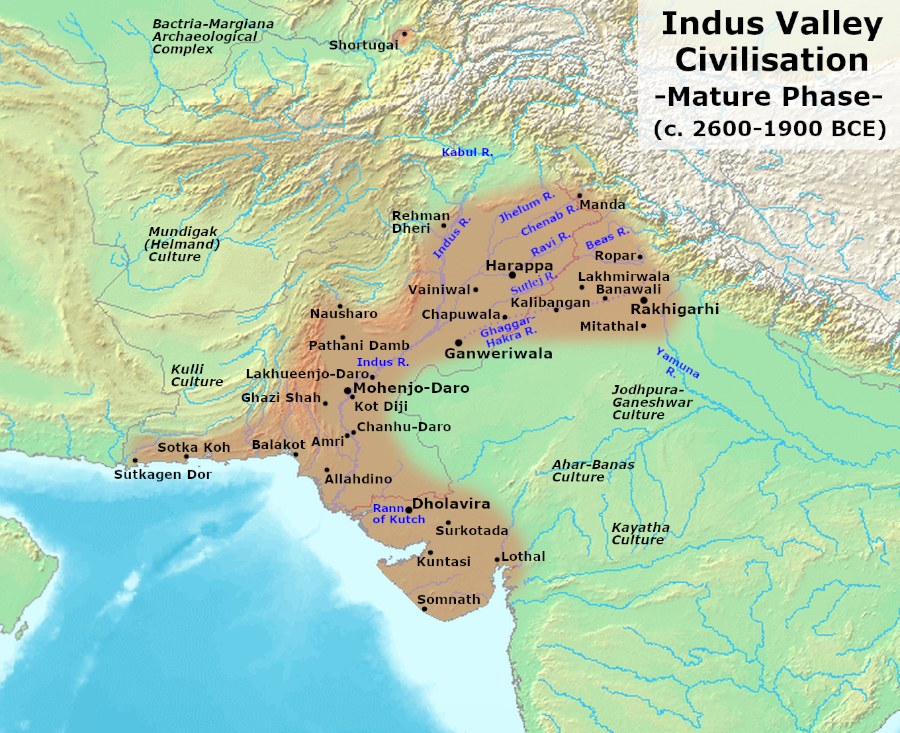
The shaded zone marks the civilisation's maximum extent; note how population centres cluster along the Indus and the Ghaggar-Hakra (postulated Sarasvati) — both river systems that a weakened monsoon would have destabilised. Map: Wikimedia Commons (public domain); reproduced for educational use.
The Research: Deoria Tal Sediment Core
- Conducted by: Birbal Sahni Institute of Palaeosciences (BSIP), Lucknow — an autonomous institute under the Department of Science and Technology (DST).
- Method: Palynology (pollen and spore analysis) on a well-dated sediment core from Deoria Tal lake, Garhwal Himalaya (~2,438 m asl, Rudraprayag district, Uttarakhand).
- Chronology: Ten Accelerator Mass Spectrometry (AMS) radiocarbon (¹⁴C) dates obtained from Trapa (water chestnut) seed cases; calibrated with OxCal 4.3 software; dating conducted at the Center for Applied Isotope Studies (CAIS), University of Georgia, USA.
- Time span covered: Mid-Holocene to present (approximately 6,000 years).
- Key proxy used: Oak/Pine pollen ratio — Oak (Quercus) thrives under moist conditions; Pine (Pinus) is more drought-tolerant. A rising Oak/Pine ratio = wetter monsoon; a falling ratio = drier monsoon.
▤ The 4.2 ka Event — Key Facts
- What: An abrupt, global climate event — a multi-decadal to multi-centennial period of severe drought and cooling — at approximately 4,200 years before present (BP, where present = 1950 CE).
- Geological significance: Defines the boundary between the Northgrippian and Meghalayan Ages of the Holocene — formalised by the International Commission on Stratigraphy (ICS) in 2018, with the Global Boundary Stratotype Section and Point (GSSP) at Mawmluh Cave, Meghalaya, India.
- Global footprint: Linked to collapses of the Akkadian Empire (Mesopotamia), Old Kingdom Egypt, the Liangzhu culture (China) and now, the Harappan urban core.
- Duration: Approximately 200 years of severe drying (~4,300–4,100 BP), embedded within a broader monsoon weakening from ~5,100 to 4,000 BP.
- Deoria Tal signal: Abrupt increase in Oak/Pine ratio at 4,250 cal yr BP, corroborating elemental (XRF) and sedimentological evidence of abrupt short-lived aridity at exactly 4,200 cal yr BP.
Climate Mechanism: What Weakened the Monsoon?
- ITCZ southward shift: The Inter-Tropical Convergence Zone (ITCZ) — the global rain belt that drives the Indian Summer Monsoon (ISM) — shifted southward in response to declining Northern Hemisphere summer insolation (solar radiation received in summer).
- El Niño intensification: A stronger phase of El Niño (warm ENSO phase) suppresses ISM rainfall; this coincided with the 4.2 ka event.
- Indian Ocean Dipole (IOD): A shift to a strongly negative IOD state (cooler eastern Indian Ocean) further reduced moisture supply to the subcontinent.
- Net effect on IVC: Reliable seasonal flooding of the Indus and Ghaggar-Hakra rivers diminished; floodplain agriculture at the edge of the Thar desert became non-viable; populations moved eastward toward the Ganga plains, where rainfall was less monsoon-deficient.
Other Holocene Climate Periods Identified
- Roman Warm Period (2,500–1,450 cal yr BP / ~550 BCE–500 CE): Strong ISM → high agricultural productivity → coincides with India's classical "Golden Age" (Gupta period and its precursors). Driver: northward ITCZ shift due to higher solar insolation.
- Medieval Climate Anomaly (1,050–650 cal yr BP / ~950–1300 CE): Strong ISM again; positive temperature anomalies, high sunspot activity, enhanced Arabian Sea winds.
- Little Ice Age (650–100 cal yr BP / ~1350–1850 CE): Weak ISM; linked to southward ITCZ shift, intensified Asian westerly jet, and warm-phase ENSO restricting northward monsoon movement.
Institutions & Terms to Know
- BSIP (Birbal Sahni Institute of Palaeosciences): Autonomous DST institute in Lucknow; India's premier palaeobotany and palaeoscience research body, named after botanist Birbal Sahni (1891–1949).
- Palynology: Scientific study of pollen, spores, and other palynomorphs (microscopic organic-walled particles) — used to reconstruct past vegetation and climate.
- AMS ¹⁴C Dating: Accelerator Mass Spectrometry radiocarbon dating — far more sensitive than conventional methods; can date milligram-scale samples.
- Holocene epochs (ICS 2018): Greenlandian (11,700–8,200 BP) → Northgrippian (8,200–4,200 BP) → Meghalayan (4,200 BP–present); India's Meghalaya gave the GSSP its name.
- ITCZ: Inter-Tropical Convergence Zone — the equatorial low-pressure belt where NE and SE trade winds meet; its seasonal northward migration drives the onset of the South Asian monsoon.
- IOD (Indian Ocean Dipole): Anomalous sea-surface temperature gradient between the western and eastern Indian Ocean; negative IOD = cooler west, warmer east → weakens ISM.
- Published in: Palaeogeography, Palaeoclimatology, Palaeoecology (Elsevier), 2026.
Figure 2 — Indian Summer Monsoon Variability and the 4.2 ka Event: Key Climate Drivers
How Four Drivers Weakened the Indian Summer Monsoon at 4.2 ka BPIndian SummerMonsoon (ISM)ITCZ SouthwardShift↓ Summer insolationEl Niño(Stronger Phase)↑ Pacific SSTNegative IOD(Strong)↓ W. Indian Ocean SSTDeclining SummerInsolation (NH)Milankovitch forcingOutcome at 4.2 ka BPIVC river systems fail → eastward migration
All four climatic drivers acted simultaneously to weaken the ISM at 4.2 ka BP, destabilising the river-dependent agricultural systems of the Harappan world.
✎ Mains Practice Question
Pollen-based palaeoclimate records from Himalayan lakes are increasingly being used to reconstruct past monsoon variability. Discuss how the "4.2 ka event" as documented from Deoria Tal connects to the spatial contraction of the Harappan Civilisation, and examine the scientific tools and proxy indicators involved in such reconstructions. 15 marks · 250 words
02
Himalayan Chandra Telescope Completes 25 Years: India's High-Altitude Optical Astronomy Milestone
GS-III · S&T — Space Science & AstronomyPrelims + MainsPIB · DST / IIA · 29 Jul 2026
The Indian Institute of Astrophysics (IIA) celebrated 25 years of continuous scientific operations of the Himalayan Chandra Telescope (HCT) at Hanle, Ladakh — the primary high-altitude optical observatory in India — with a three-day conference and the announcement of two major upcoming telescopes.
◈ Background & Context
India's optical astronomy ambitions in the high-altitude trans-Himalayan region date to the mid-20th century, but geographical and logistical constraints long delayed their realisation. The search for an ideal Indian observatory site was formally initiated following a Planning Commission recommendation.
- Need for a high-altitude site: Optical and near-infrared telescopes require stable, dry, clear-sky conditions with minimal atmospheric water vapour — qualities found only at high altitudes above the monsoon cloud layer.
- Search process: IIA was designated the nodal agency in 1989; from 1993, teams surveyed six Himalayan locations before selecting Digpa-ratsa Ri, Hanle, Ladakh at 4,517 m asl.
- Why Hanle? The Himalayas block the southwest monsoon clouds, yielding more than 250 clear observing nights per year; precipitable water vapour below 2.5 mm enables near-infrared work; extreme remoteness minimises light pollution.
- Foundation stone: Indian Astronomical Observatory (IAO), Hanle — laid 1997.
- First Light: 26 September 2000. Dedicated to the nation: August 2001.
Figure 3 — The Himalayan Chandra Telescope at Hanle, Ladakh (4,517 m asl)
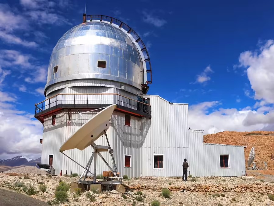
The silvered dome of the HCT sits atop Digpa-ratsa Ri at 4,517 m — one of the world's best sites for optical and near-infrared astronomy. The INSAT-3B satellite dish (foreground) enables real-time remote operation from Bengaluru. Image courtesy PIB / IIA; reproduced for educational use.
▤ HCT — Key Facts at a Glance
- Full name: Himalayan Chandra Telescope (named after Nobel Laureate Subramanyan Chandrasekhar, 1910–1995)
- Aperture: 2-metre diameter optical/infrared reflecting telescope
- Location: Digpa-ratsa Ri, Hanle, Leh district, Ladakh — 4,517 m asl
- Operating institution: Indian Institute of Astrophysics (IIA), Bengaluru — autonomous DST institute
- Remote operation: Operated in real time from IIA campus, Hosakote, Bengaluru via dedicated INSAT-3B satellite link (ISRO) — since June 2001
- Observing capacity: >250 usable nights/year; precipitable water vapour <2.5 mm
- First scientific result: Optical afterglow study of a gamma-ray burst (GRB), 2001
- Current instruments: HFOSC (optical spectrograph & camera) · uTIRSPEC (near-IR spectrometer & imager) · HESP (high-resolution Echelle spectrograph)
Scientific Contributions Over 25 Years
- Planetary science: Spectroscopy of comets; exoplanet atmosphere studies; contributed to discovery of TRAPPIST-1b (one of seven Earth-sized planets around an ultra-cool dwarf star).
- Stellar astrophysics: Infrared imaging of star-forming regions; long-term monitoring of young stellar objects and variable stars; spectroscopic surveys of binary systems, emission-line stars, and chemically peculiar stars.
- High-energy phenomena: Optical follow-up of novae, supernovae, and gamma-ray bursts; study of expanding nebular shells.
- Extragalactic research: Mixed stellar populations, low-surface-brightness galaxies, lensed quasars, interacting galaxies, reverberation mapping of active galactic nuclei (AGN).
- Training: Has trained multiple generations of astronomers from institutions across India.
Hanle as a Growing Astronomy Hub
- GROWTH-India Telescope (IIT Bombay): a 70-cm robotic telescope for time-domain astronomy (transients, asteroids).
- MACE Telescope (BARC): Major Atmospheric Cherenkov Experiment — world's highest imaging atmospheric Cherenkov telescope (4,270 m); detects very-high-energy gamma rays.
- HAGAR (TIFR): High Altitude GAmma Ray telescope array.
- Hanle Dark Sky Reserve: Recently designated to protect the pristine night sky for future facilities — one of India's first dark sky reserves.
- Upcoming (Union Budget announcement): 3.7-m Upgraded HCT and 13.7-m National Large Optical-Infrared Telescope (NLOIT) — both to be led by IIA at Hanle.
About Subramanyan Chandrasekhar
- Indian-American astrophysicist (1910–1995); born in Lahore; educated at Presidency College, Madras and Cambridge.
- Derived the "Chandrasekhar Limit" (~1.4 solar masses) — the maximum mass of a stable white dwarf; beyond this limit, a star collapses into a neutron star or black hole.
- Nobel Prize in Physics, 1983 (shared with William Fowler) for theoretical studies of the physical processes important to the structure and evolution of stars.
- Spent most of his career at the University of Chicago; was a long-time editor of the Astrophysical Journal.
✎ Mains Practice Question
The Himalayan Chandra Telescope (HCT) at Hanle represents a successful model of remote-operated, high-altitude astronomical infrastructure in India. Discuss the scientific significance of HCT's 25-year contributions and critically examine the institutional and policy frameworks that have enabled Hanle to evolve into a multi-facility astronomy hub. 10 marks · 150 words
Polity, Governance & Social JusticeGeneral Studies Paper II
03
DAANVEER Initiative: Citizen-Powered Digital Infrastructure for Gram Panchayats
GS-II · Polity — Local Governance, Panchayati RajGS-III · Economy — Digital InfrastructurePrelims + MainsPIB · Ministry of Panchayati Raj · 29 Jul 2026
The Ministry of Panchayati Raj has launched DAANVEER — a voluntary, technology-mediated citizen participation initiative that allows individuals and organisations to donate pre-approved computer bundles directly to digitally underserved Gram Panchayats through the Meri Panchayat mobile application.
◈ Background & Context
Panchayati Raj Institutions (PRIs) constitute the constitutional foundation of grassroots democracy in India. The 73rd Constitutional Amendment Act, 1992 gave constitutional status to Gram Panchayats and mandated the State governments to devolve functions across 29 subjects listed in the Eleventh Schedule.
- Scale: India has approximately 2.5 lakh (250,000) Gram Panchayats, covering the bulk of the country's ~6.5 lakh villages.
- Digital governance challenge: Despite an expanding digital governance ecosystem — e-GramSwaraj (fund tracking), AuditOnline (social audit), Sabha Saar (Gram Sabha records), Gram Manchitra (spatial data) — many Gram Panchayats lack basic computing hardware to operate these platforms.
- Lineage of voluntary giving models: DAANVEER builds on India's historical tradition of community contribution (shramdaan, temple trusts, village funds) while introducing a verified, end-to-end digital framework to address trust and accountability deficits in unstructured donation models.
▤ DAANVEER — Initiative at a Glance
- Full name: DAANVEER ("Philanthropic Hero" — a portmanteau of Daan [donation] + Veer [hero/warrior])
- Tagline: "Give Back to Your Village"
- Nodal Ministry: Ministry of Panchayati Raj
- Developed in collaboration with: National Informatics Centre (NIC) and DigiHaat
- Access platform: Meri Panchayat mobile application (integrated with DigiHaat marketplace)
- What can be donated: Standardised, quality-verified computer bundles mapped to State-specific technical specifications
- Tracking: End-to-end digital tracking from dispatch to installation; digital certificate of appreciation for donors
- Eligible donors: Citizens and organisations in India and the Indian diaspora globally
- Nature: Entirely voluntary; not a government levy or CSR mandate
How the Platform Works
- Donor accesses the Meri Panchayat app → selects an eligible Gram Panchayat → chooses from pre-approved computer bundles → delivery address auto-populates → order placed on DigiHaat marketplace.
- Delivery and installation is tracked digitally; donor receives a certificate of appreciation on completion.
- Eligible Gram Panchayats are listed in the app; States have their own technical specifications that determine which computer bundle is appropriate.
Critical View
- Demand-supply asymmetry: Hardware alone does not bridge the digital divide; adequate power supply, broadband connectivity (BharatNet progress), and trained Gram Panchayat Development Officers (GPDOs) are co-requisites that DAANVEER does not address.
- Voluntary model limitations: Donation flows are likely to be uneven — wealthier Gram Panchayats with diaspora networks may receive more donations than the most underserved. A purely voluntary mechanism may deepen intra-State inequities.
- Maintenance lifecycle: Computer bundles require ongoing maintenance; the initiative does not specify a maintenance or replacement mechanism.
- Scale vs. need: 2.5 lakh Gram Panchayats represent a substantial hardware gap; voluntary donations are unlikely to cover the full need without parallel budgetary provisioning.
Key Panchayati Raj Digital Ecosystem Platforms
- e-GramSwaraj: Unified platform for Gram Panchayat planning, accounting and fund tracking (2020).
- AuditOnline: Digital social audit management tool for PRIs.
- Sabha Saar: Digital capture and repository of Gram Sabha proceedings.
- Gram Manchitra: GIS-based spatial planning tool for Gram Panchayats.
- Meri Panchayat App: Citizen-facing interface for PRI services, now the access point for DAANVEER.
- DigiHaat: Government-affiliated digital marketplace; integrated as the procurement backend for DAANVEER.
Figure 4 — DAANVEER Donation Flow: From Citizen to Gram Panchayat
Donor opensMeri PanchayatAppSelects eligibleGram Panchayatfrom listChoosescomputer bundle(DigiHaat)Dispatch &digital trackingend-to-endInstallationat GramPanchayatDigitalCertificateissuedFully voluntary · No paperwork · Transparent end-to-end · Open to diaspora globally
The six-step DAANVEER flow eliminates paperwork through DigiHaat integration, making remote or diaspora participation straightforward.
✎ Mains Practice Question
India's Panchayati Raj institutions have been at the centre of digital governance reforms over the past decade, yet the digital divide at the grassroots persists. Critically evaluate the DAANVEER initiative as a model of citizen participation in strengthening local self-governance, and discuss the structural constraints that voluntary mechanisms alone cannot address. 15 marks · 250 words